STEM,Farming & Agro-allied
Cocoa Farming Early Detection & Warning Systems
Editor
created
Jul 17, 2025 12:56 PM
Building an early detection and warning system for your cocoa farm as a cocoa farmer, staying ahead of threats like pests, diseases, and unpredictable weather is critical to protecting your yield and livelihood. An early detection and warning system can help you monitor risks and act swiftly. Here’s a concise guide to key areas you should explore when building such a system for your cocoa farm.
1. Disease and Pest Detection
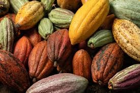
Cocoa crops face threats like black pod disease and pod borers. Use IoT cameras and AI-powered image recognition to spot early signs of trouble, such as leaf discoloration or pod damage. Drones can also scan large farms for infestations, sending alerts for targeted interventions like spraying. Studies show AI systems can detect diseases with up to 95% accuracy, saving crops before outbreaks spread.
2. Weather and Climate Monitoring
Rainfall and humidity heavily influence cocoa health. Install affordable weather stations to track local conditions and integrate satellite data for forecasts. Automated alerts can warn you of conditions ripe for fungal diseases, helping you act proactively. In West Africa, SMS-based weather alerts have cut farmer response times by 40%.
3. Soil and Water Management
Healthy soil and proper irrigation are vital for cocoa trees. Soil sensors can monitor moisture, nutrients, and pH, while smart irrigation systems adjust water flow based on real-time data. These tools can boost yields by 15-20% in water-stressed regions like Ghana, while reducing waste.
4. Farm Security
Theft and wildlife can harm your harvest. Motion sensors and AI-powered cameras around your farm’s perimeter can detect intruders or animals, sending instant mobile alerts. In Côte d’Ivoire, such systems have reduced theft by 30%.
5. Yield and Sustainability Tracking
Monitor cocoa pod growth with drones or IoT sensors to predict yields and catch issues early. Additionally, use satellite imagery to ensure sustainable practices, like avoiding deforestation, to meet certifications like Rainforest Alliance.